This article provides insights into cosine‘s space scientific instrumentation for operational use and their importance for modern space industries.
This article delves into the significance of space-based Earth Observation and planetary science, the role of cosine in this domain, and the transformative impact of their advanced remote sensing technologies used in operational contexts with a scientific approach, smart processing, smart calibration, and application development.
Introduction
Space technology has transformed various industries, including communication, weather forecasting, navigation, and environmental monitoring. Among these advancements, remote sensing from space with various techniques, widely known as satellite-based Earth observation, stands out as an essential capability, providing unparalleled viewpoints and insights to modern industries. Private organizations like cosine are at the forefront of this change, offering cutting-edge remote sensing technologies, spanning from passive spectral imaging and spectropolarimetry to active LIDAR imaging, with short delivery times to power-up your project’s remote sensing capabilities and help you comprehend the Earth and beyond, combining the scientific approach with the industrial mindset. This article further delves into the innovative approaches and technologies provided by cosine that empower the next generation of space remote sensing capabilities.
Importance of space-based remote sensing
The socio-economic impact of space-based remote sensing is significant. The Earth observation sector serves a wide range of commercial and defense applications, such as environmental monitoring, agriculture, real estate, insurance, and intelligence- surveillance-reconnaissance (ISR). Satellite data is also useful for policymakers and scholars working on sustainable development goals.
The ability to better monitor and manage natural resources, plan urban growth, and respond to calamities results in significant economic savings and a higher quality of life. Furthermore, space-based imagery encourages international collaboration by allowing governments to share data and knowledge to solve global issues like climate change and disaster resilience.
Key technologies and innovations by cosine
cosine derives its knowledge from extensive technology development experience within astrophysics, planetary science, and Earth observation missions. The state-of-the-art technology development within the group cross-fertilizes the different business lines, continuously bringing the best in quality solutions to the market.
Spectral imaging
Spectral imaging, including multi- and hyperspectral, involves collecting and analyzing data from throughout the electromagnetic spectrum. Unlike conventional imaging, which only records pictures in a few bands, hyperspectral imaging captures data in hundreds of small bands. This enables a more thorough and precise investigation of materials, surfaces, and phenomena. cosine’s hyperspectral cameras are used in environmental monitoring, mineral exploration, and agriculture, among other applications. Thanks to the powerful onboard processing capabilities, the instruments deployed by cosine in the market find the best use within early warning applications, where the time from satellite fly-over to information delivery is of crucial importance.
cosine owns the SCOUTTM product line, a variety of cutting-edge multi- and hyperspectral imagers in continuous evolution with state-of-the-art hardware and software products, thanks to the steady operational experience in space performed by cosine for its own missions, as well as supporting customers through the complete mission cycle.
The line includes the HyperScout series of space-based hyperspectral imagers, the TScout high-resolution multi-spectral infrared imager, and POLA, the space-based spectropolarimeter. These compact and smart imagers may be deployed on CubeSats, small and micro-satellites within a few months, thanks to cosine’s advanced on-site production strategy, making them ready, affordable, and providing high-quality data powered by smart onboard and ground processing tools. If desired, you can also benefit from the support of cosine’s scientists, who can assist customers from operating the instruments in space to developing their own applications, either to be deployed within the instruments in space or to be run as part of the ground infrastructure.
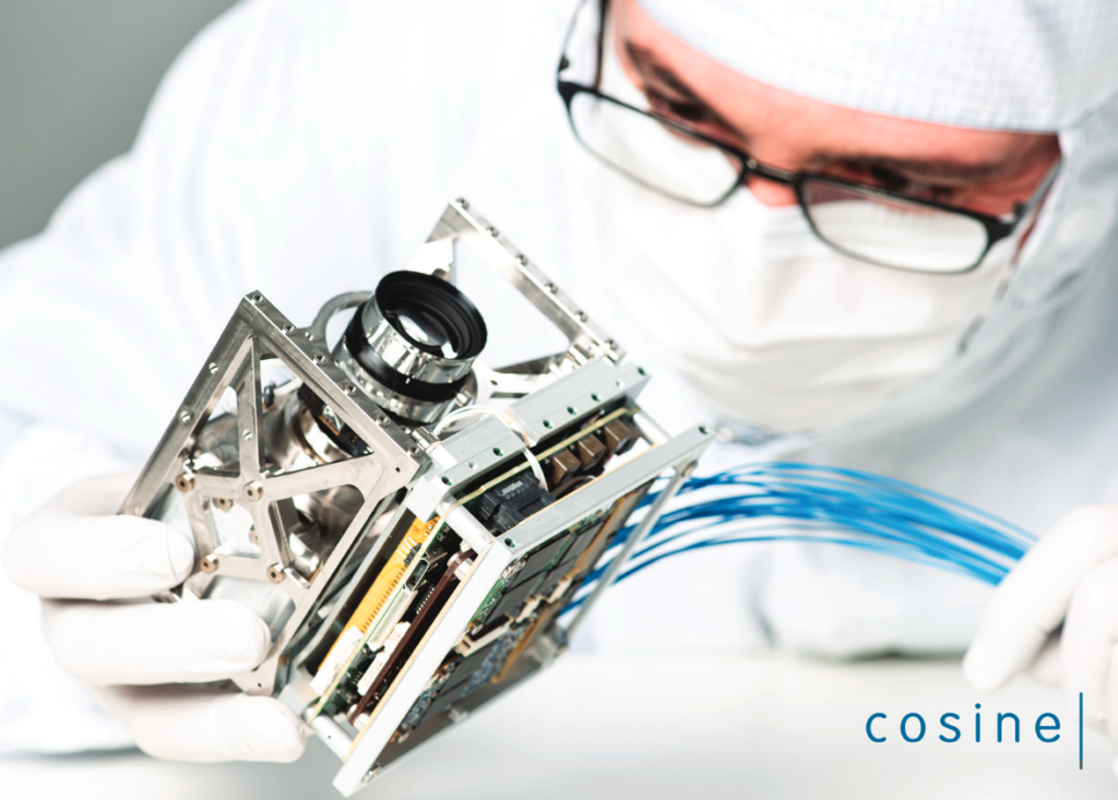
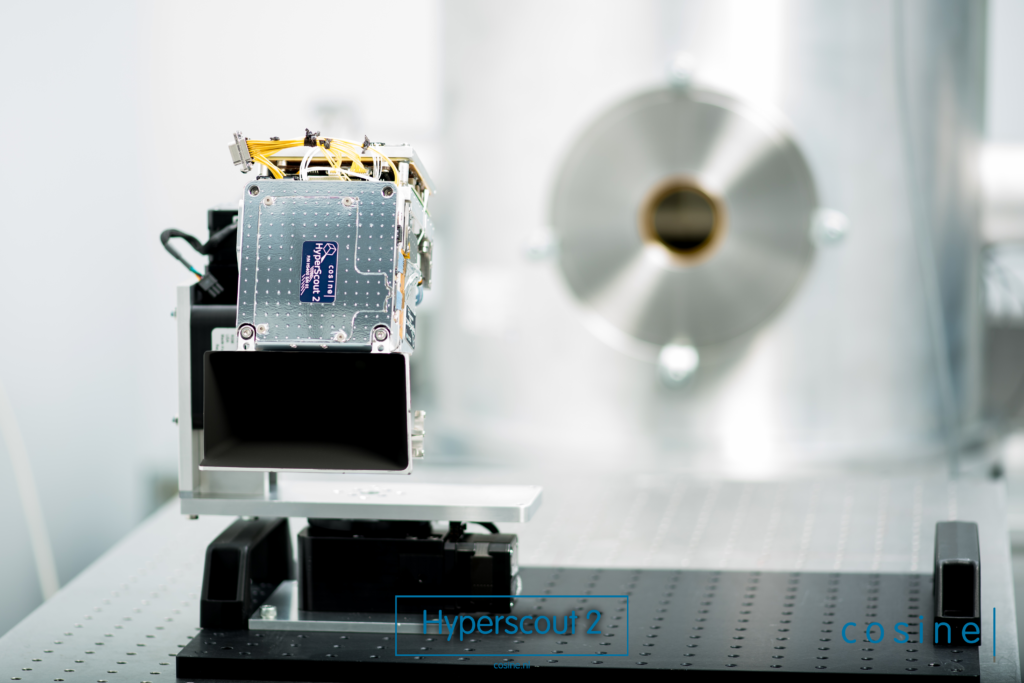
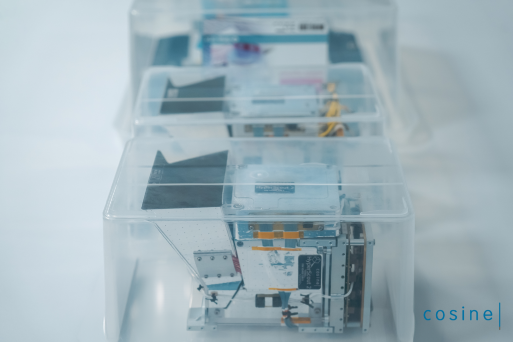
Realize your own remote sensing application with a ready-to-use HyperScout 2 or HyperScout M from the available stock. These cutting-edge instruments are produced in frequently renewed batches at cosine and are ready to power-up the spectral and thermal imaging capabilities of your project almost immediately.

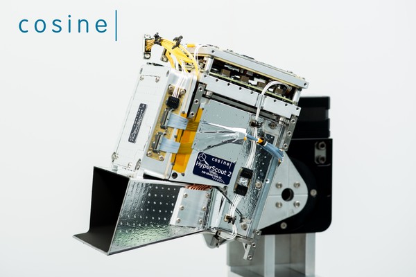
The cosine Remote Sensing HyperScout 2 is a hyperspectral imaging camera with VNIR and TIR (8-14 µm) channels for nano, micro and larger satellites. The system features an athermal telescope system, BEE/OBDH, MMU and ICU. For accelerating machine vision tasks, the Vision Processing Unit (VPU) can be equipped optionally. The systems has achieved flight heritage.
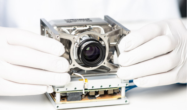
The cosine Remote Sensing HyperScout M is a hyperspectral imaging camera with VNIR (450-950 nm) channels designed to fit a CubeSat unit. The system features an athermal telescope system, BEE/OBDH, MMU and ICU. For accelerating machine vision tasks, the Vision Processing Unit (VPU) can be equipped optionally.
Miniaturized imaging systems
Space technology is moving towards downsizing, driven by the demand for cost- effective and scalable solutions. Miniaturized imaging systems allow satellites to be smaller, lighter, and consume less power without sacrificing operational capability.
cosine specializes in creating durable and efficient optical systems with short delivery times. Their miniaturized sensors are suitable for CubeSats, small, as well as micro satellites, allowing highly valuable remote sensing techniques from platforms that are much smaller and less expensive than standard satellites. These systems are critical for Earth monitoring, disaster management, and city planning.
Onboard processing and Artificial Intelligence
The use of onboard processing and artificial intelligence (AI) by cosine offers several key advantages. These technologies enable real-time data analysis, reducing the need for extensive data transmission and lowering associated costs. They enhance the autonomy of space instruments, allowing for immediate decision-making without waiting for ground control instructions. Additionally, AI improves the accuracy and efficiency of data interpretation, identifying patterns and anomalies swiftly. This flexibility and customization capability ensure that instruments can adapt to new challenges and mission requirements effectively. cosine can help you develop applications fitting your needs, which you can address both on the ground and in orbit.
By aggregating spectral and thermal imaging in one instrument, you can perform in orbit a number of applications, e.g., retrieving the water stress of your agricultural fields as well as the soil water content of a region with a size of 300 km per image shot.
Hand-in-hand collaboration
cosine helps you understand the applications with in-house scientists, providing data upfront. They support customers throughout the entire process and beyond, from hardware selection to the use of the instrument in space. This includes smart calibration, smart data processing, and application development.
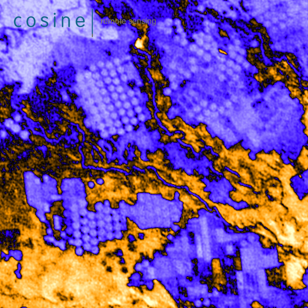
cosine’s science-based DNA provides customers with added value support during the entire mission cycle, including very important mission phases such as calibration with conventional approaches as well as experimenting with advanced cross-calibration kernels developed in research projects using artificial intelligence. In the images above, you see the cross-calibration of HyperScout 2 spectral reflectance with Sentinel 2, results endorsed by ESA having certified HyperScout data as a third-party contribution to Copernicus.
Supporting the Copernicus missions
The knowledge base at cosine is sharpened by continuous involvement in the development of advanced algorithms for the calibration and data enhancement of worldwide atmospheric Copernicus missions such as Sentinel VP and Sentinel 4. The same knowledge and algorithms make the commercial SCOUT product line the best in the market in terms of price to quality ratio.
The above picture showcases the effects of instrumental errors in the retrieval of anthropogenic gas distribution from the Sentinel 5P satellite (Urbas et al, 2012).
Industrially produced instruments
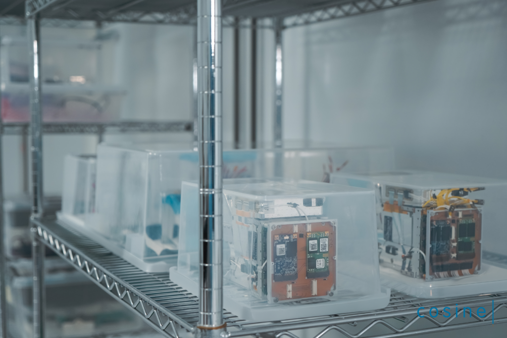
cosine has organized a batch production line for the SCOUTTM instruments. Thanks to this production process, it is possible to deliver a number of instruments shortly after the customer order, enabling missions with critical time-to-market requirements.
Future prospects
The field of space-based imaging is constantly changing, with new technologies and breakthroughs appearing regularly. cosine is committed to remaining at the forefront of these improvements, investing in R&D to improve its remote sensing capabilities. Future prospects include the creation of ever more compact and lightweight imaging devices, improved resolution and accuracy, and the incorporation of artificial intelligence into data analysis.
Despite the high potential, there are several hurdles to overcome in the field of space-based imaging. These include the high costs of launching and operating satellites, the necessity for reliable data processing and storage options, and the complications of international cooperation and regulation. cosine is actively addressing these challenges through innovation, strategic collaborations, and adherence to industry standards.
Conclusion
cosine is at the forefront of space remote sensing technology, developing novel solutions to improve the capabilities of space-based platforms. Their advances in spectral imaging, miniaturized systems, and high-resolution optics are transforming a variety of applications, including environmental monitoring, agricultural management, urban planning, and planetary exploration. As the area of satellite imaging advances, cosine is well-positioned to lead the way with new technologies and methodologies that will deepen our understanding of the Earth and beyond.
To find out more about cosine, and their available stock of miniaturized hyperspectral imagers, please view their supplier hub here on the satsearch platform.