Episode 18 of the Space Industry podcast is a discussion with Simera Sense about the technical and commercial drivers of change in the EO industry, including constellations, bandwidth selection, deployable systems, satellite imagery data sources, and more.
Contents
Episode show notes
In this episode we speak with Thys Cronje, Chief Commercial Officer of Simera Sense. Simera Sense is an optical payload manufacturer based in South Africa, and is a member of the satsearch membership program. In the podcast we cover:
- The frequency bands that are currently under-addressed in planned EO constellations.
- Why some companies choose to vertically integrate EO business units, while others use more external suppliers.
- The scope for deployable EO payloads to potentially provide better resolution imagery in the same size of satellites.
- The current structure of the market (including relationships between space agencies and private companies) and predictions of future developments.
The product portfolio of Simera Sense

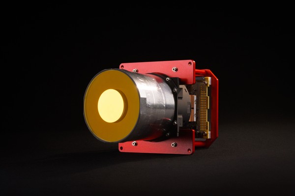
Simera Sense's HyperScape100 is a hyperspectral push-broom imager primarily designed for Earth Observation (EO) applications, as a payload for CubeSats. It is based on a CMOS image sensor and custom continuously variable optical filter in the visible and near-infrared (VNIR) spectral range.
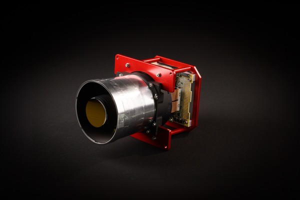
Simera Sense's MultiScape100 CIS is a multispectral push-broom imager for Earth Observation (EO) applications. It is based on a CMOS imaging sensor and a 7-band multispectral filter in the visible and near-infrared (VNIR) spectral range. It provides continuous line-scan imaging in up to 7 spectral bands, each with digital time delay integration (dTDI).
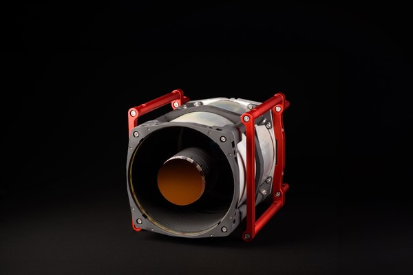
Simera Sense's MultiScape200 CIS is a multispectral push-broom imager for Earth Observation (EO) applications. It is based on a CMOS imaging sensor and a 7-band multispectral filter in the visible and near-infrared (VNIR) spectral range. It provides continuous line-scan imaging in up to 7 spectral bands, each with digital time delay integration (dTDI).
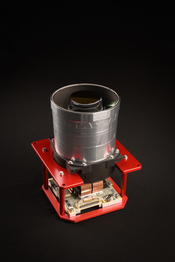
Simera Sense's TriScape100 is a red-green-blue (RGB) colour snapshot imager for Earth Observation (EO) applications. It is based on a 12.6-megapixel CMOS imaging sensor with integrated RGB Bayer filter in the visible spectral range, and provides snapshot imaging with a frame rate of up to 150 full resolution frames per second (FPS).
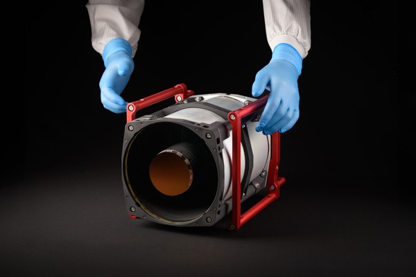
Simera Sense's TriScape200 is a red-green-blue (RGB) colour imager, as a primary payload for smallsats. It is based on a 65-megapixel CMOS imaging sensor with integrated RGB Bayer filter in the visible spectral range, and provides snapshot imaging with a frame rate of up to 30 full resolution frames per second (FPS) at 10-bit pixel depth.
Episode transcript
Hello, everybody, I’m your host Hywel Curtis. I’d like to welcome you to ‘The Space Industry’ by satsearch, where we share stories about the companies taking us into orbit. In this podcast, we delve into the opinions and expertise of the people behind the commercial space organizations of today, who could become the household names of tomorrow. Before we get started with the episode, remember, you can find out more information about the suppliers, products, and innovations that are mentioned in this discussion on the global marketplace for space at satsearch.com.
Hello, and welcome to today’s episode. Today I’m joined by Thys Cronje, Chief Commercial Officer at Simera Sense. Simera Sense is an Earth Observation company based in South Africa and is a member of the satsearch membership program. The company manufactures optical payloads for clients around the world and supports mission teams with design, integration, and operation.
Today, we’re going to discuss some of the factors that are driving commercial demand for Earth Observation payloads. But firstly, Thys, I’d like to welcome you to the Space Industry podcast and ask if you’d like to add anything to that introduction.
Thank you very much. And thanks for the opportunity to join you here today. I think you’ve nailed it with your introduction, and there’s not much more that I can add.
Fantastic. Okay, well, let’s dive into today’s topic. Earth Observation is obviously a huge part of the industry; of the NewSpace sector as we know it today. I wonder if you could just provide a quick overview of some of the key drivers that are leading to Earth Observation satellites, you know, really taking off in the last few years?
Yes, we have definitely seen an explosion in the demand for Earth Observation instruments over the last couple of years. There can be various reasons or drivers for that, but I have tried to isolate a few.
So, over the last decade, the industry got quite a bit of attention. And when I say industry I mean the NewSpace industry, with attention on commercial players across the value chain.
We think about SpaceX and Blue Origin, and all those big companies getting a lot of attention. But now they are really putting us in the spotlight. And then you’ve got companies like Planet and Satellogic that are showing the industry that commercial Earth Observation is possible with smaller satellites. So that’s playing a bigger role in the perception of industry.
Due to this growth, we are seeing more investors joining the party as well. The access to capital is fueling this growth. With all of these developments, it’s becoming much easier to get into space for smaller companies. To be honest, getting into space is not a challenge anymore. And then the demand for Earth Observation data is growing as well.
Today, we are seeing even insurance companies using Earth Observation data to deliver products to small farmers across Africa. And even in India. It is no longer only governments procuring Earth Observation data, but also startups.
And then free data from space agencies also gave the industry quite a boost. Think about the feedback of the whole Copernicus programme. It’s changing our whole perspective on this industry. We’ve seen advancements in technology like advanced processing. We are in a perfect storm.
Great, interesting. So lots of factors at play really, both on the public and private side. I think we hear a lot of talk about small satellite constellations. They capture the public imagination quite easily and obviously there are multiple topics that are discussed about them in terms of traffic management and all sorts.
But there are lots out there that are planning daily revisits to certain parts of the world. When we think about those technical challenges that they face in terms of the actual Earth Observation payloads that they have, what sort of bands and resolutions do you think are under-addressed in the existing constellations, or those that are planned, but would have really deep value for end users?
That’s a good question. I think you’ve made a good observation there. At Simera Sense, we are seeing a huge demand for especially hyperspectral instruments and instruments that can provide spatial resolutions of below one metre GSD on a daily basis. We are getting requests for those type of instruments.
However, there is not a silver bullet answer to your question. I believe the question that the new players in the Earth Observation industry must ask is, what challenge or problem are we trying to solve for our customers. The problem you’re trying to solve then will determine your spectral, spatial, and radiometric resolution that is required.
We all understand that Earth Observation instruments are actually a measuring tool. It measures something. You are usually measuring some form of activity on the Earth from space and you need an answer from that. Now, the question is, how accurate does that answer need to be? 95%, accuracy 85% or 50%? It’s all determined by your application.
Now, this will feed back into your choice of spectral, radiometric and spatial resolution. Let’s say for instance, with the old example of people who might want to count cars in a parking lot to determine economic activity. Now, how accurate do you want that number to be? Of course, is it 99.99% accuracy required? Or is 80% accuracy good enough?
So yes, that’s a big driver in your choices for spectral, spatial, and radiometric resolution. But that said, from a smaller satellite perspective, the longer wavelengths are still pretty under-addressed. But we are seeing a lot of action in that sector as well. I would recommend anybody that wants to fill a gap in the small CubeSat kind of Earth Observation industry to look a little bit at the longer wavelengths and forget about spatial resolution.
Right. Interesting. Yeah, very much application-driven, problem-solving considerations there. Just to turn briefly to things from from a supplier’s point of view. Now, there are lots of different approaches in the industry to setting up a commercial service or a business case, or a business itself, based on Earth Observation technologies.
Now, we’ve seen operators that are vertically integrated to produce their own payloads, such as Planet who you mentioned earlier, whereas others are sourcing cameras from suppliers like yourselves, and then integrating that into the systems that they’re developing. What is your take on these two approaches? Obviously, you have a lot of interest in the one area, but I just wondered what you thought about these two approaches in the industry?
Yes, we think pretty much a lot about it. But it’s a question. And I think as engineers, we love the challenge of building vertically-integrated companies focusing on a product. But as I said earlier, our focus is on the specific needs or problems that you want to solve while the real challenge is more related to your business model innovation. I think one should focus a lot more on that.
But then again, it’s also about how much control you want to exercise over your whole value chain. So for companies like Planet, it’s good for them to do this vertical integration, because then they’ve got the whole value chain under their control.
But for us, first of all, I believe you need to focus on the strengths. Focus on what you are good at, and where you can add the most value. For the rest, you can form a nice innovative partnership with a supplier like us, and then let us do the heavy lifting where you’re weak.
Second thing, there are a lot of risks in developing optical payloads. It’s difficult. Take it from me, it’s not that simple. You need the know-how and the infrastructure. And the infrastructure takes time and money to develop and scale. A company like Planet Labs to go from one optical payload to 150 optical payloads, it’s a totally different ballgame. There is a lot of investment that needs to go into that.
Lastly, I think in business terms, the time to market is everything. If you first need to develop the infrastructure to develop your payload, then you’ve got a long and bumpy road ahead of you. So that’s my belief on your question.
I think the fact that it is possible to create these partnerships and develop your own supply chain, from what we’ve seen and the teams that we’ve worked with, is more achievable today than it was even 10 years ago, which is a good thing for the whole industry.
Looking at the performance of the Earth Observation payloads themselves, people usually want to squeeze as much performance as possible within the physical limitations of the satellite bus. And the smaller the satellite, the more crucial these decisions and compromises become.
I wonder if you could give a bit of an overview of the scope of Earth Observation payloads in small satellites. What sort of resolutions can be achieved in a CubeSat form factor for example? What decisions need to be made from an engineering point of view?
Yes, I think you’re 100% correct there. It’s the story of my life” I need to explain to customers that one meter GSD is not possible with a 12U CubeSat or a 6U CubeSat. There is a perception that it must be possible. Just make this pixel smaller. But it doesn’t work like that. Not at all. And the physics are quite simple. You can’t play dice with the physics.
For instance, for a 100-millimetre aperture system, you are limited to about 4m GRD. GRD is Ground Resolve Distance. So that’s what your optical system allows you to see. In the visible and near-infrared range from 500 kilometres, it’s about 4 metres. It won’t help to go smaller than that.
As soon as the wavelength goes longer than that the limit also is higher. So for instance, for a 200-millimetre aperture, which you can use easily in a 12U, or a 16U kind of cubesat, the limit is just above 1.5 meter from 500 kilometers.
So yes, there’s lots of physical limits and then there are some other things that you also need to address and that can influence your GSD. There’s the stability of the satellite. You need a very good ADCS to make sure that you can achieve that high resolution. The thermal stability of your instrument must also be very stable, because any form or variations in your instrument can influence the GSD as well.
But that said, GRD and GSD are not the end of it. One must also ask how much contrast or modulation you want to transfer from the image to the object. Now we are a little bit spoiled with large satellites that have gotten into MTF of about 25 to 30%. But you must ask yourself will 5% also do the job. And again, you need to look at your specific application, and especially your budget.
For a given application, there is always an optimal cost efficiency versus instrument accuracy point. It is the entrepreneur’s job to find that specific point where he wants to operate for his specific application. And that is where companies like us can play a role, to assist customers making those kinds of choices regarding GSD, MTF, spectral resolution and radiometric resolution. I suppose it’s quite a few balls you need to keep in the air!
So this is going back to that application, as you say; if you need 80% accuracy for the cars you counted in the car park, do you need one meter GSD and 25% MTF? Possibly not.
Another area of the technology that in general in small satellites that people have been talking about quite a lot is deployable systems. And obviously, Earth Observation payloads have a lot of complexity, and there’s a lot of sensitivity involved in terms of the thermal and mechanical stability, as you’ve discussed. But do you see that there could be scope for deployables in Earth Observation payloads in coming years in order to engineer better resolution of imagery within the same size satellite?
Yes, I think you’re saying is quite right. We see a lot of activity in that domain already, but only on a limited level, not commercial yet. So yes, I think in the next 5 to 10 years, deployable systems will become a reality as the technology evolves and matures. It’s really something that we will evolve towards. And it’s nice.
But it won’t come without its risks and challenges and you’ve mentioned a few of them, the thermal stability, the accuracy. We polish our mirrors to the tenth of a wavelength and that’s the kind of accuracy you need, and to align your systems to. When doing that in space, in a deployable, it’s not easy. But the short answer is yes. I think within the next 10 years we will frequently see deployable systems in space.
Interesting. And to go back, we’ve mentioned briefly about the different bands, and the services and the applications that can form within them. Now beyond RGB, multispectral, SAR, there’s also a bit of interest in imaging in hyperspectral, SWIR bands. Do you believe that the time is coming for these bands to garner more major commercial interest? And even for constellations to be established in such bands as well?
Yes, definitely. I definitely believe so. The longer wavelengths are still a little bit untapped and can unlock a wealth of information about our planet. Just think about resource management, mining, and pollution monitoring; it’s much more information for those sectors in the longer wavelengths than only in the visible wavelength. By sampling these wavelengths in more detail, we will be able to monitor a lot of challenges here on Earth much more accurately.
We are already seeing a few commercial players entering the shortwave infrared, as you mentioned, and in the thermal infrared spectrum, with nice and innovative business models. There are quite a few of them that are starting to develop and so within the next 5 years observation within these bands will become standard, and will give us a whole new perspective of our planet. With this new applications will also develop.
And then consider the data that will be connected from such new innovative business models and constellations, and obviously, all the existing satellites and constellations that we have today. You mentioned earlier that part of what’s driving a big boom in interest in Earth Observation systems is the availability of free data from space agencies.
Do you see, moving forward, there being sort of a standard industry setup where commercial operators are mainly driving the Earth Observation segment using some of the free data from space agencies? In this industry, do you think that there are lots of sovereign countries that would increasingly prefer using such commercial imagery rather than acquiring it themselves through their national space agencies?
Yes, I think you summarised the game beautifully, that free data from space gave the commercial players a major boost over the last 10 to 15 years. I mean the application developers. Suddenly the application developers have really good data to work with for free with, with which they develop a lot of new applications and use that data as real nice test bench for future applications and for higher resolution data.
I’m of the opinion that free data from space agencies have moved the whole Earth Observation industry from a technology push to a demand cycle, and especially from the application side. And that’s quite nice. On the back of this, as commercial Earth Observation operators and new players, we are able to identify gaps within the market and position ourselves to address these needs and gaps.
Now Earth Observation is becoming actually a commodity today. A few years ago, it was still a luxury or niche, but now we see it’s becoming a necessity. So data prices will come under pressure and the focus will shift to value-added services, away from only providing data.
And yes, government or public organizations cannot develop and operate Earth Observation constellations as cost-effectively as the commercial sector. And this will drive the shift towards using commercial imagery. Just think of Planet Labs. How effectively they are managing that constellation and distributing the data.
No. I don’t see governmental organizations operating that way. The same with SpaceX. The costs that they can launch rockets into space. The governmental sectors or agencies can’t do that. In short, as Earth Observation data is becoming a commodity, governments will source data from commercials suppliers more frequently. It’s just what will happen.
Yeah, like you say the ability for application developers to focus more on value-added services, and the innovation that could result in, could be good for everybody. So that’s great to see now.
I think just as a final question, we’ve touched on quite a few actually, of your different predictions in different areas for the Earth Observation industry. I wonder if there’s anything else that you thought is likely to happen in the next three to five years, or anything that you are particularly excited about at Simera Sense, or that you see as opportunities for the industry in general. I wonder if you could put your predicted hat on and share the future with us?
It is always nice to try to look into a glass bowl. That’s a frequent topic in our company as well to try to look into a glass bowl and predict what’s going on. But I think the trends that we do see today are that Earth Observation instruments are generating a lot of data. Way more than then we can use.
I’ve heard numbers that only 5% to 10% of the data downloaded are actually being used. So they’re just lost. It’s either not usable or not interesting. So I think the focus of the next 3 to 5 years will be on how we can we handle all this data in a more cost-effective manner, and optimise the data paths, and get rid of the inefficiencies in the system.
It will be all about addressing and streamlining the bottlenecks within the value chain. Therefore, a lot of focus will be on on-board processing to get the information and ultimately the insight that you need as fast as possible in the hands of the correct decision-maker. And we will try to short circuit those loops.
With this will also we will also see a lot of Earth Observation products being integrated into various decision-making processes, especially in the retail, financing and insurance industries. Earth Observation will play a major role in how our agricultural, or the green and especially the blue economies, are being financed and insured. We will see a lot of applications and in places and the use of Earth Observation the way we traditionally haven’t been used in the past.
So in short, the way the industry is consuming the Earth Observation data will change dramatically over the next 5 years. A lot of application developers are currently focusing on just that. And that will have a direct impact on the instrument manufacturers who are approaching optical payloads. So yes, in short, the next 3 to 5 years are going to be extremely exciting for the whole Earth Observation industry.
And yes, we as a company can’t just wait for that. We will try always to drive that process and work across the value chain with partners who make all of these things happen.
Oh, well, fantastic. I think that’s a great place to wrap up. I think you will have taught our listeners a lot today about all the different aspects of the Earth Observation industry, and how all these criteria play into each other and affect each other. Thank you very much for sharing these insights with The Space Industry podcast community today.
Yes, I must thank you, and thanks for this platform and opportunity. I think it’s great to have these kind of discussions. Thanks a lot.
Great. You’re welcome. And thanks to all our listeners out there. Remember, you can find out more details about Simera Sense’s portfolio and services, and history of the company on our platform satsearch.com. You can also make free requests for further technical information, documents or quotes, lead times and introductions to companies or whatever other information you might need for your trade studies or procurement purposes. Thank you very much.
Thank you for listening to this episode of The Space Industry by satsearch. I hope you enjoyed today’s story about one of the companies taking us into orbit. We’ll be back soon with more in-depth, behind-the-scenes insights from private space businesses.
In the meantime, you can go to satsearch.com for more information in the space industry today, or find us on social media, if you have any questions or comments. To stay up to date, please subscribe to our weekly newsletter. And you can also get each podcast on demand on iTunes, Spotify, the Google Play Store, or whichever podcast service you typically use.
Please note – we’ve tried to ensure that this transcript is as accurate as possible, though some edits have been made to improve clarity. It is possible that there are some errors or inconsistencies with the podcast audio recording – if you have any questions or comments on this please let us know at [email protected] today.