This is part of a series of articles by satsearch called “Let’s talk about” – designed to help fulfill our mission of democratizing access to the space industry.
October the 4th 1957 will forever be remembered by space enthusiasts. It was on this day that the Soviet Union launched the first ever artificial satellite, Sputnik-1. This single mission had kick-started the 20-year Space Race that eventually culminated in man landing on the surface of the Moon in 1969.
Interestingly, the launch of Sputnik-1 also led to an area of the space industry that is still relevant more than 60 years later – and is in fact leading to new applications, commercial opportunities and technological innovation on a regular basis, particularly due to the advent of machine learning and artificial intelligence.
This area is known as Earth Observation (EO).
So what exactly are EO satellites (also known as remote sensing satellites)? How did they come into existence and what role do they play in our lives today? Let’s talk about it.
What is Earth Observation?
Earth Observation (EO) is the process of gathering data about planet Earth’s physical, chemical and biological systems via remote sensing technologies, which is further augmented by analysis and presentation of the information collected. In particular, changes in both the Earth’s natural and built environments are rigorously monitored through various EO techniques.
Lower launch costs and smaller, more economical satellites have meant that data from EO has become increasingly available and more widely used in modern society. In addition, technological advancement in the electronics industry has led to the collection and analysis of EO data in increasing volumes and quality.
Today EO data are used in a wide variety of applications, bringing value to many different classes of user. Some of the specific areas of applications (PDF) include:
- weather forecasting,
- tracking biodiversity and wildlife trends,
- measuring land use change,
- monitoring and responding to natural disasters,
- managing natural resources such as energy, freshwater, and agriculture,
- addressing emerging disease and other health risks,
- and most importantly, assessing and helping to combat the effects of climate change.
Note that EO can be performed through satellite remote sensing as well as airborne sensors (drones) and ground-based sensors. However, in this article we will only be concerned with satellite-based EO carried out using of remote sensing technology.
When did Earth Observation begin?
The origins of Earth Observation can be dated back to the 1840s.
The earliest forms of EO technology were simply cameras attached to balloons, providing the first-ever aerial photographs. This was followed by the use of kites and carrier pigeons deployed in the same manner for the next 50 years.
Like most technologies, aerial photography saw significant progress during the World Wars. During World War 1 reconnaissance aircraft flew over enemy forces to observe troop movements with the help of ordinary camera mounted on planes.
The first time our planet was imaged from a camera situated in space was in 1946. A V-2 rocket launched from White Sands, New Mexico, took this picture of the Earth from an altitude of 65 miles.

However, aerial photography is just one of many EO applications in use today.
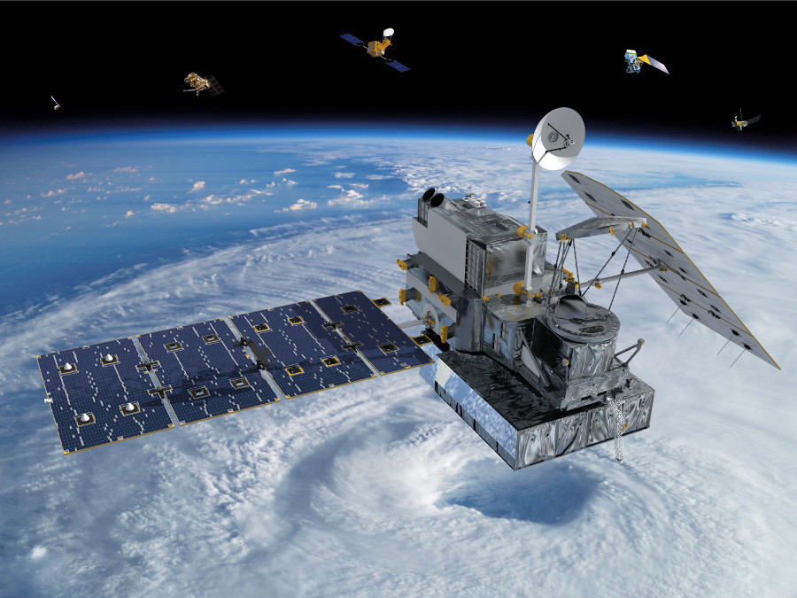
To focus just on EO satellites, the launch of Sputnik-1 also heralded a new era of satellite remote sensing. Sputnik-1 successfully obtained data pertaining to the density of the upper layers of the atmosphere and the propagation of radio signals in the ionosphere.
This achievement was followed by Explorer-1, the first satellite sent by the United States into space. Explorer-1 was equipped with a cosmic ray detector designed to measure the radiation environment in Earth’s orbit which led to the discovery of the Van Allen belts.
The decades following this saw many other countries throughout the world launching EO satellites to serve different national interests. By the end of 2018 there were 684 active satellites orbiting the Earth for the purpose of EO and Earth science.
What is remote sensing and how is it used?
Remote sensing is the process of gathering information and monitoring the physical characteristics of an area by measuring the reflected and emitted radiation. It is performed at potentially great distances and is vital in a wide variety of applications such as:
Agriculture – where it is used as a mapping tool to examine the health of the crops and monitor farming practices. Remote sensing is also deployed in soil, water and drought monitoring.
Atmosphere monitoring – in which it enables weather analysis and provides a wealth of information about how human activities are causing climate change. Such data plays a vital role in raising awareness among the general public.

Mitigating natural disasters – one of the most effective uses of EO data is in numerical weather prediction models which can help in the development of better predictions of many types of natural disaster. Informed by such models, mitigation measures can be put in place faster, such as the evacuation of people from areas likely to be affected. The recent cyclone in India is a prime example of how important EO information can be; with the help of accurate data and prediction models, the number of casualties was reduced to a single figure.
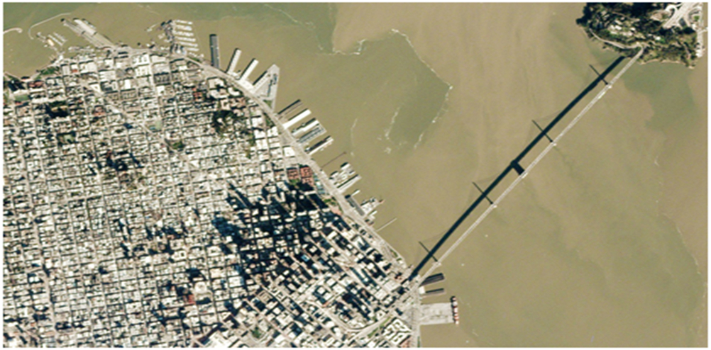
Urban mapping – remote sensing not only helps us analyze natural environments, but also assists with planning and monitoring urban areas. The rapid advancement of technology and urbanization of large parts of the world has led to complex urban environments with changing patterns of traffic, business use, climatic conditions and sustainability requirements, and there are many ways that remote sensing can add value in such locations.
So how does remote sensing actually work?
Remote sensors gather data from the emitted and reflected radiation from the Earth’s surface, covering the entire electromagnetic spectrum. This gives us the capability to observe and analyze objects not visible to the naked eye.
Some spectral bands are extremely useful in classifying land cover for example. Each type of land cover has a unique spectral signature enabling accurate classification, so we can better understand vegetation distribution throughout the planet.
Remote sensing can basically be divided into two parts:
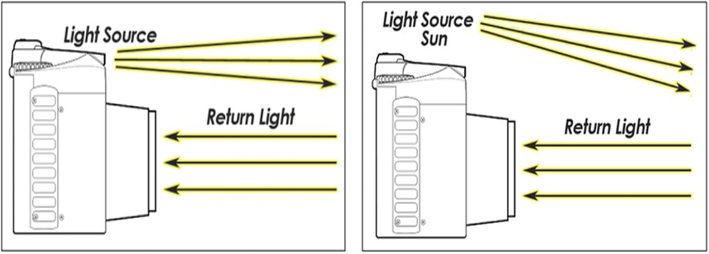
- Active remote sensing in which the sensors have their own source of illumination, and do not depend on natural light, and the energy that is reflected back from the target is measured.
- Passive remote sensing in which the reflected light that is emitted from the sun is measured.
The diagram below shows the difference between the two:
The image resolution gathered through remote sensing can also be categorized as spatial, temporal and spectral.
Spatial resolution is the measure of the clarity and pixel size of an image; the higher the spatial resolution, and the smaller the pixel size, the clearer the image.
Temporal resolution is the frequency with which the satellite revolves around the Earth and the time taken by the photons to reach the sensors. Sometimes the target might change its characteristics by the time light reaches the sensors. Hence, longer the light has to travel, the lower the temporal resolution will be.
Spectral resolution is the amount of spectral detail in a spectral band. A higher spectral resolution means bands are narrower, such as in the hyperspectral region, whereas a lower spectral resolution features broader bands that cover more of a spectrum.
Remote sensing technology has come a long way in recent years and new applications, methods and approaches continue to emerge.
Factors driving the EO industry
There are several commercial factors that are generating innovation and progress in the Earth Observation industry:
Cheaper access to data – the most significant factor is the increased availability of data due to an exponential growth in the number of satellites. Commercial launch services have reduced the cost of access to space through innovative solutions such as reusable rockets and rideshare options. Rockets are therefore launching more frequently and are deploying a higher volume of satellites into orbit.
In addition, the growth of the smallsat industry (including CubeSats, microsats, minisats, and nanosats) has been important. Small satellites have significantly less development time and are cheaper to manufacture. This has led to an increase in the number of satellites in space, and hence a reduction in revisit times, ensuring that Earth Observation is more accurate and effective and making EO data cheaper and more available than ever before.
Providing value-added services – recent advancements in big data collection and analysis solutions, and cloud processing capabilities have also led to a shift in the EO industry. Customers now expect not just raw data, but also useful insights and analysis.
Cloud processing helps EO data providers store huge volumes of data while also enabling faster and easier analysis. And this is leading to a key trend in the industry – satellite operators are transforming into companies that provide value-added services, not just firms that manufacture and operate equipment.
The rise of the NewSpace economy – Venture capitalists invested $3.25 billion into space technology companies in 2018, an increase of 29% percent according to Seraphim Capital. The scale of this investment is ushering in a new era for the EO industry as one of the biggest beneficiaries of this increased investment.
Small satellite constellations – there are currently a range of satellite constellations planned in sectors outside of Earth Observation, such as the large OneWeb and Starlink constellations designed to bring space-based internet to large parts of the world. It is possible that new manufacturing approaches and technologies used in the development of these constellations could cross over to be used in the development of EO satellites in the future.
Artificial Intelligence (AI): Last, but definitely not least, AI is making a mark in almost every sector, on Earth and off. With better machine learning algorithms analyzing satellite imagery is becoming quicker and easier than ever before. Only around 3-5% of relevant satellite observations are actually used in preparing numerical weather forecasts for example; the use of AI would help forecasters process and use more of these data and hence enable better accuracy for weather forecasting models.
The major players
With the ease of launching into space, due to the rise of commercial spacecraft, the industry has seen an increased number of companies getting into the EO sector. Here are some of the most significant firms:
Planet: Founded in the year 2010 by Will Marshall, Planet has single-handedly transformed the smallsat industry with its own breadbox size satellites known as Doves. Through the use of commercial-off-the-shelf (COTS) electronics in satellites it has also been able to lower the cost of production drastically.
In addition, the company’s in-house manufacturing facility gives it the flexibility to produce products at a faster rate, according to the needs of the customer. With over 200 EO satellites and the ability to monitor every ‘pixel’ of Earth 24 hours a day, 7 days a week, Planet has become a real game-changer in the EO industry.
Spire Global – Founded in the year 2012 by Peter Platzer, Spire Global launched its 100th satellite earlier this year; one of its trademark Lemur satellites aboard ISRO’s Polar Satellite Launch Vehicle (PSLV). Spire is actively involved in Earth Observation for both data and analytics purposes, and it mainly focusses on areas that are not easily tracked by other platforms.
Aside from providing data for weather forecasts, it also specializes in tracking planes, ships, and other vehicles in remote regions. The company has several worldwide offices and had an impressive 160% year-over-year revenue growth at the end of 2018.
Satellogic – Headquartered in Buenos Aires, Satellogic was founded in the year 2010 by Emiliano Kargieman with the aim of providing high-resolution hyperspectral data to the industry. Combining this with the capability to stream high-resolution data, the company aims to provide daily updates on infrastructure issues, crop health, pipeline integrity and similar information to a range of clients.
Earlier this year, the company announced a plan to launch 90 satellites into low Earth orbit to remap the planet at one-meter resolution every week. The first 13 are expected to launch in September or October this year.
With more than 150 satellite engineers, solution specialists and experts in AI, the company has raised closed to $80 million in funding to date.
The future of the EO market
The Earth Observation industry is growing at a very fast pace, evolving continuously and adopting innovative new technologies to cater to the needs of a growing population. As the demand for EO data explodes, the EO industry will become a major vertical in the space sector taking a bigger chunk of the market.
But the future of the EO industry does not depend only on companies providing data; as mentioned above it is also seeing significant growth through the provision of analytics services. The GeoBuiz-18 report discovered that the downstream segment of the space sector, which primarily includes the imagery/mapping analytics market, is expected to approach US $42.3 billion in 2020. It is therefore very important for businesses in this space to focus on effective data analytics as well as capture, so that better decisions can be taken here on Earth with the help of accurate satellite information.
Another trend that is expected to play a crucial role in the future of the EO industry is the rise of the 4th Industrial Revolution. With new emerging technologies such as AI and machine learning, big data, cloud tech, and Internet of Things (IoT), the way we collect, analyze and process EO data will be transformed significantly. With companies such as Planet already developing the capability to image each and every part of Earth 24/7, finding new ways to leverage this data for the benefit of humankind, in conjunction with 4th Industrial Revolution technologies, could bring a wide range of new capabilities to services here on Earth.
The direction of the NewSpace age will be influenced not only by reusable rockets and eye-catching missions to Mars, but also by applications that can exploit the enormous amounts of data collected by EO satellites. With the miniaturization of sensors and satellites, a growth in entrepreneurial approaches to space missions, and increasing levels of investment in the space sector; more private companies are expected to enter this market in order to solve problems on Earth using EO solutions in ways that have not been possible until now. The future sure looks exciting!
Wait, we are not quite done yet! Since you’ve read this far you have hopefully found this discussion of Earth Observation interesting. To help you continue to increase your knowledge in this area, here is some of the best further reading we have collected from around the web, Enjoy!
- Barbara J. Ryan recognized for her contributions in Earth Observation. We need more such people, don’t we?
- Hyperspectral- the next Earth Observation frontier?
- Seeing energy from space
- Space tech to diagnose bowel cancer
- Still not convinced? Here are 100 applications for Remote Sensing technology{target=”_blank”}
Ad Astra!